|
||||
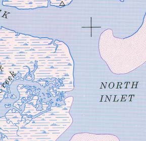
North Inlet |
|
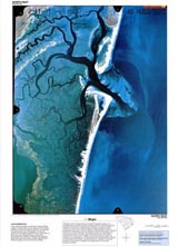
Portion of NAPP infrared photograph (1989) showing part of North Inlet. |
Portion of topographic map from USGS North Inlet quadrangle.(1973) |
North Inlet (NAPP)
|
North Inlet (Topo)
|
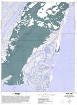
RationaleHurricanes have visited the South Carolina coastline repeatedly both during recorded and prerecorded history. Some of these unwelcome visitors have ruined entire harvests, flooded plantations and cities, destroyed houses and businesses in coastal communities, and killed thousands of people. During several of these hurricanes, storm wave action has cut through barrier islands to create new tidal inlets, washed beach sand over into marsh lands, and significantly altered the shape of the coastline. The North Inlet Study Site highlights the physical changes that Hurricane Hugo produced in the Winyah Bay area of South Carolina as seen from a comparison of two aerial photographs, one taken before the hurricane and one taken just after the storm. It also provides an opportunity to recount tales of prior hurricanes in this part of the state and to analyze human reactions to this type of natural disaster. |
Background InformationDescription of Landforms
Influence of Topography on Historical Events and Cultural Trends
Natural Resources, Land Use, and Environmental Concerns
|