 |
||||
Table Rock(Mountains) |
|
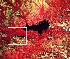
Portion of NHAP infrared photograph (1981) of Table Rock Reservoir (black) with Table Rock outcrops (white) to the southwest Outlined area corresponds to the topographic map to the right |
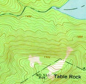
Portion of topographic map of Table Rock from Table Rock USGS quadrangle (1978). Table Rock Reservoir is shown in the upper right corner (blue). |
Table Rock (NHAP) |
Table Rock (Topo Map) |
RationaleThe Table Rock Mountain region is an excellent example of Blue Ridge topography, land use, and wildlife habitat. At 3,124 feet above sea level, the mountain itself is one of the highest in South Carolina. Its sheer cliffs and bare rock exposures create spectacular scenic views characteristic of this mountainous region. Waterfalls abound on steep mountain slopes, and numerous hiking trails lead not only to the summit of Table Rock Mountain, but also to a variety of unique habitats and forest ecosystems at lower elevations. Table Rock Mountain is the major attraction in Table Rock State Park, one of South Carolina's oldest and best known parks, which has recently become a major tourist attraction for the whole southeastern region of the United States. The park area also reveals a diverse human history, both Native American and colonial, as well as a rich heritage of folk tales and traditions. The recent influx of tourists has replaced logging as the major economic resource and created a demand for even more development which has in turn created much controversy over how best to manage the land for so many different and sometimes contradictory purposes. |
Background InformationDescription of Landforms
Influence of Topography on Historical Events and Cultural Trends
Natural Resources, Land Use, and Environmental Concerns
|


