 |
||||
Woods Bay |
|
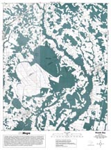
Portion of NAPP infrared photograph of Woods Bay (1989). Bay is the dark feature located in the center of image. |
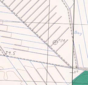
Portion of topographic map From USGS Turbeville quadrangle (1983). This area is from a drained bay near the one shown to the left (note drainage features). |
Woods Bay (NAPP) |
Woods Bay (Topo) |
RationaleOf all the landforms in South Carolina that have aroused the curiosity of both geologists and local residents, Carolina Bays are at the top of the list. Woods Bay was selected as the Carolina Bay study site because it is the largest Bay preserved in a near-pristine condition and also because it is one of the most easily accessible, being located just south of Interstate Highway 95 on the border of Clarendon, Florence, and Sumter counties. In the 1920's, most of the cypress trees were logged, and tramways were laid over swampy areas to allow timber to be hauled out. In 1971, logging companies were prevented from repeating the harvest when Woods Bay was made a state park. It contains both swampland areas and grassy savanna areas, as well as pine barrens along its sand rim. A cypress-tupelo community dominates the interior of the Bay, while longleaf pines cover the drier rims. Woods Bay stands in sharp contrast with nearby Dials Bay, which was drained for agricultural use. The park is a refuge for many varieties of birds, amphibians, reptiles, and mammals, as well as to a host of rare and specialized plants. |
Background InformationDescription of Landforms
Influence of Topography on Historical Events and Cultural Trends
Natural Resources, Land Use, and Environmental Concerns
|


