 |
||||
The Ace Basin |
|
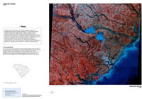
Portion of Landsat infrared satellite image of the ACE Basin (1983). |
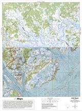
Portion of topographic map of the ACE Basin from the Walterboro USGS quadrangle (1990). |
Coastal Satellite Image - |
ACE Basin (Topo) |
RationaleThe ACE Basin area has been designated a high-priority habitat under the North American Waterfowl Management Plan because of its importance to migrating birds and a variety of threatened and endangered animal species. In addition to the ecologically significant features of the ACE Basin, which include both freshwater and saltwater marshes, a rich historical tradition is still preserved which includes old plantation homes, Civil War forts, historic graveyards and churches, and a thriving Low Country culture. The coast around the ACE Basin preserves remains of the earliest settlements in the state and highlights the significant contributions of the black culture which dominated the area in the past and continues today as an influential part of South Carolina society. |
Background InformationDescription of Landforms
Influence of Topography on Historical Events and Cultural Trends
Natural Resources, Land Use, and Environmental Concerns
|


