Below is an Index Map to the South Carolina Study Sites.  Click on a Study Site number to view examples of images, maps, and exercises.  You may also select a site from the site study index. Note that a Statewide Overview is also available.


sc study sites clickable map


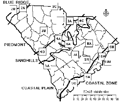
Index to Study Sites

2A  Table Rock (Mountains)  5B  Santee Cooper Project (Engineering & Canals)
2B   Lake Jocassee (Energy Production) 6A   Congaree Swamp (Pristine Forest)
3A  Forty Acre Rock (Granite Outcropping) 7A   Lake Marion (Limestone Outcropping)
3B   Silverstreet (Agriculture) 8A  Woods Bay (Preserved Area)
3C  Kings Mountain (Historic Battleground) 9A  Charleston (Historic Port)
4A   Columbia (Metropolitan Area) 9B   Myrtle Beach (Tourist Area)
4B   Graniteville (Mining Area) 9C  The ACE Basin (Wildlife & Sea Island Culture)
4C   Sugarloaf Mountain (Wildlife Refuge) 10A  Winyah Bay (Rice Culture)
5A   Savannah River Site (Habitat Restoration) 10B  North Inlet (Hurricanes)