

| Damage | Study Areas | Motion records | In-situ Test | Album | Publications | References |
![]()
After the 1999 Chi-Chi earthquake, a series of field investigations were carried out by various teams from government agencies, engineering firms, and universities. In-situ tests such as Standard Penetration Test (SPT), Cone Penetration Test (CPT), and shear-wave velocity measurements (Vs) were performed along with laboratory tests in these investigations. As part of this study, in situ test data along with field observations were collected and verified. These included in-situ tests conducted at Yuanlin, Dachun and Shetou by Moh and Associates Inc. (MAA, 2000a), tests conducted by MAA at Nantou and Wufeng (MAA, 2000b), and tests conducted by Resources Engineering Services Inc. (Yu, 2001, personal communication) at Nantou and National Cheng Kung University (Lee, 2001, personal communication) at Yuanlin, Nantou, Wufeng, Dounan and Zhangbin Industrial Park (Lunwei and Lukang).
These study areas are shown in Figure 3 along with major faults and the epicenter (Chi-Chi) of the 1999 earthquake. The figure is shown with local coordinate system with the unit of meter.
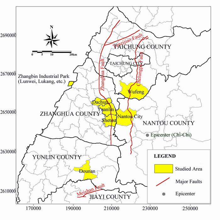
Figure 3. Areas studied in this research project
Figure 4 shows the general geological conditions in Central West of Taiwan. For the areas suffered the most from liquefaction in the Chi-Chi earthquake, including Yuanlin, Nantou, and Wufeng, additional geologic maps and information are provided.
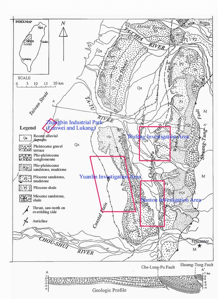
Figure 4. Geologic Map of Central Western Taiwan
 Yuanlin: The town
of Yuanlin is situated
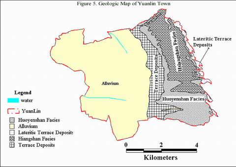
on a thick alluvial deposit of Tsosui River at the foothill of Baguashan. Soil
conditions in the relatively flat portion of Yuanlin west of Shan-Jao Road
consist of Holocene alluvium, which overlies older
sedimentary deposits (Stewart et al., 2000). The depth to the bedrock increases
from east to west, reaching a depth of more than 200 m (Ueng et al., 2000).
Figure 5 shows a geological map of Yuanlin.
Yuanlin: The town
of Yuanlin is situated
on a thick alluvial deposit of Tsosui River at the foothill of Baguashan. Soil
conditions in the relatively flat portion of Yuanlin west of Shan-Jao Road
consist of Holocene alluvium, which overlies older
sedimentary deposits (Stewart et al., 2000). The depth to the bedrock increases
from east to west, reaching a depth of more than 200 m (Ueng et al., 2000).
Figure 5 shows a geological map of Yuanlin.
Figure 6 shows a typical soil profile at Yuanlin based on the investigation conducted by MAA (2000a). Ground water table is quite shallow, ranging from about 0.5 to 4.0 m below the ground surface. There exist layers of very loose sandy soils that are susceptible to liquefaction. There is generally a thick layer of clayey soils at the western part of Yuanlin, which becomes thinner towards the eastern side of the town. At some locations, however, sand deposits exist near the ground surface with little or no capping clayey layer. Severe damages to buildings were generally found at sites with little or no capping clayey layers. At sites with capping clayey layers, sand boils generally were not observed, although in many of these sites, ground subsidence and/or titling of buildings were still observed.
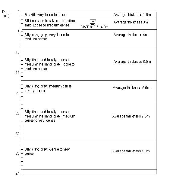
Figure 6. Typical soil profile at Yuanlin
 Nantou: The liquefaction evidences in Nantou during the Chi-Chi
earthquake included sand boils, building subsidence, and lateral spreading.
Locations of "obvious liquefaction" such as sand boils and lateral
spreading are mainly along the Mau-Lou River that runs through Nantou and in the
Juin-Gong district, which is to the east of downtown Nantou (NCREE, 2000;
Stewart et al., 2000).
Nantou: The liquefaction evidences in Nantou during the Chi-Chi
earthquake included sand boils, building subsidence, and lateral spreading.
Locations of "obvious liquefaction" such as sand boils and lateral
spreading are mainly along the Mau-Lou River that runs through Nantou and in the
Juin-Gong district, which is to the east of downtown Nantou (NCREE, 2000;
Stewart et al., 2000).
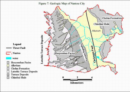
The geologic deposit at Nantou generally consists of Holocene alluvial sediments with shallow ground water (2 to 5 m below the ground surface). The area is formed by alluvial sector and deposit plains that are mainly composed of cemented or poorly-cemented clay, silty sand, sand and gravel distributed on valleys and alluvial plateau. Figure 7 shows a geological map of Nantou. Typical soil strata at Nantou generalized from the SPT boreholes and CPT soundings conducted by MAA (2000b) are shown in Figure 8.
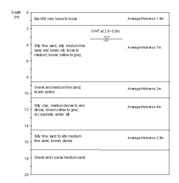
Figure 8. Typical soil profile at Nantou
 Wufeng:
The evidences of liquefaction in Wufeng during the Chi-Chi earthquake
included sand boils, building subsidence, tilting and failure, and lateral
spreading. Locations of "obvious liquefaction," indicated primarily by
sediment boils, are on the alluvial deposits, west of the fault. Some of the most
damaging lateral spreading occurred at the south end of Wufeng, and involved
movement towards the Dove Nest Creek. Differential foundation settlement was the most commonly observed ground failure in these areas.
According to Chu et al. (2000b), severe damages at
Wufeng were not only due to the Chelungpu fault passing through the area but also
due to its geological and hydrological conditions such as the existence of old
river channels.
Wufeng:
The evidences of liquefaction in Wufeng during the Chi-Chi earthquake
included sand boils, building subsidence, tilting and failure, and lateral
spreading. Locations of "obvious liquefaction," indicated primarily by
sediment boils, are on the alluvial deposits, west of the fault. Some of the most
damaging lateral spreading occurred at the south end of Wufeng, and involved
movement towards the Dove Nest Creek. Differential foundation settlement was the most commonly observed ground failure in these areas.
According to Chu et al. (2000b), severe damages at
Wufeng were not only due to the Chelungpu fault passing through the area but also
due to its geological and hydrological conditions such as the existence of old
river channels.
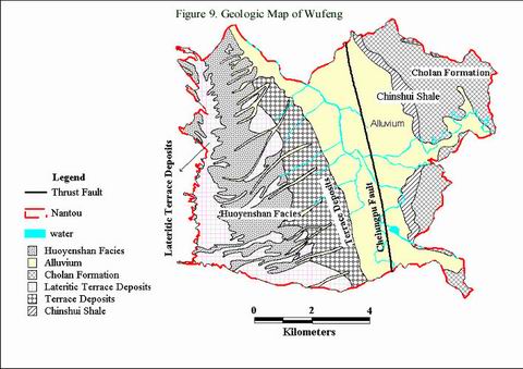
As shown in Figure 9, the near surface geological formation at Wufeng is the alluvial plain of the Quaternary deposits (Chu et al., 2000a). Stratified rock formation can be found at shallow depths in the eastern part of Wufeng, which is a deposit from the age of Pliocene and Pleistocene. The alluvium at the western part of Wufeng consists of silts, sands, gravels, and cobbles eroded from the foothills and transported by the Kan creek. Ground water is generally shallow (0.5 to 5.0 m below the surface). Figure 10 shows typical soil strata at Wufeng.
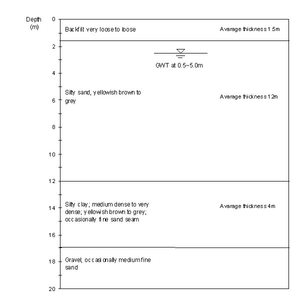
Figure 10. Typical soil profile at Wufeng
![]()
© ALL Rights Reserved
Clemson University