Navigation Systems
- Basic Description
-
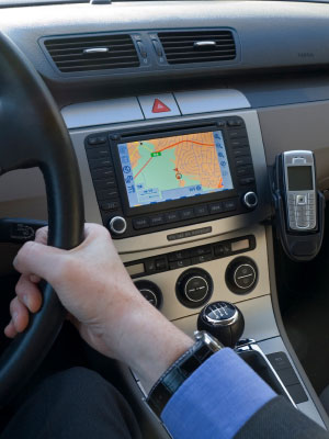
Navigation systems help the driver of a vehicle to locate a particular destination and identify the best route for getting to that destination. Most automotive navigation systems use Global Positioning System (GPS) signals and electronic maps to identify the vehicle's current position relative to the desired destination. Portable navigation systems powered through the cigarette lighter or batteries, can be easily moved from vehicle to another. Built-in navigation systems have the advantage that they can access information about the vehicle's speed and direction to help navigate in situations where a GPS signal is temporarily blocked by buildings, traffic, foliage, etc.
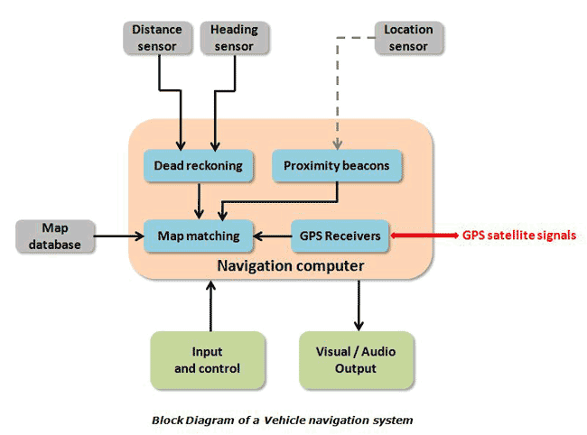
Although the vast majority of automotive navigation systems rely on GPS signals, proximity beacons provide another form of radio-positioning. Proximity beacons are devices installed at key intersections and other strategic roadside locations that communicate their location along-with other information to receivers in passing vehicles via very short range radio, microwave or infrared signals. The reception of a proximity beacon signal provides an occasional basis for confirming vehicle position. One such system is described here.
Vehicle navigation systems generally offer the option of a top view (or bird's eye view) that shows the position of the vehicle on a traditional map; or a forward view that shows the road ahead as it would be viewed by the driver.
The diagram below illustrates the inputs and outputs associated with a navigation system that employs both GPS and proximity beacons.
Some navigation systems are integrated with real-time traffic information and emergency notifications that are transmitted to the vehicle wirelessly (e.g. at cell phone or FM radio frequencies). Using this information, the system is able to compare multiple routes and find the quickest one. It can then continue monitoring to see if one of the routes becomes quicker based on traffic and adjust accordingly.
Navigation apps that rival or exceed the quality of in-car navigation systems are becoming standard on many smartphones. Apple introduced CarPlay in early 2014 at the Geneva Motor Show. CarPlay allows navigation, among other features, from a connected iPhone to be displayed and interacted with using the car's in-dash display and controls. Android introduced Android Auto in mid 2014 for Android smartphones as a direct competitor to Apple's CarPlay. Both systems use the GPS and sensors of the connected phone for navigational data that is then relayed to the vehicle's entertainment system for display. Real-time traffic data may be downloaded using the phone's cellular data depending on the application being used for navigation.
The Global Positioning System
The U.S. military maintains 24 to 31 satellites orbiting the earth at any given time that are used for the GPS system. There are also 3 to 4 decommissioned satellites in orbit that can be reactivated if needed. They travel around the earth twice everyday and are arranged in such a way that at least 4 satellites are visible from any point on the earth at any time. To use GPS, a vehicle must have a GPS receiver. The GPS receiver has a pre-stored map or almanac of the position of each satellite (which is updated based on information sent out by the satellite). The GPS receiver determines its distance from one satellite. Now, the receiver might be at any point on the surface of a sphere (say, Sphere A) with a radius equal to the distance from this satellite. Now, if the receiver measures its distance from a second satellite, it obtains another sphere (say, Sphere B) of probable positions. Sphere A and Sphere B will intersect to form a locus of possible locations that would be a circle. With distance information from a third satellite, there are only 2 possible locations remaining, and only one of these two positions is on the Earth's surface.
A GPS navigation device receives information from satellites in the form of high-frequency, low-power radio signals. Radio signals travel at the speed of light and the GPS receiver measures the distance between itself and the satellite by finding the time taken for a radio signal to travel between the satellite and itself. However, to be able to measure this, the satellite and the receiver require extremely accurate clocks. The satellites have an atomic clock; most commercial receivers employ an ordinary quartz clock. The receiver measures incoming signals from 4 or more satellites, which is more information than necessary just to establish position. The additional information is used to update the receiver's quartz clock to maximize the accuracy of its position calculations.
- Sensors
- GPS receiver, gyrocompass, accelerometer, vehicle speed sensor
- Actuators
- Display
- Data Communications
- Control Unit Communication: Typically Control Area Network (CAN) Bus System
- Manufacturers
- Aisin,
Alpine,
Bosch, Clarion,
Cobra,
Continental,
Delphi,
Denso,
Garmin, JVC, Kenwood,
Magellan,
Magneti Marelli, Mio,
Navman, Pioneer, Rand McNally,
TomTom
- For More Information
- [1] Automotive Navigation System, Wikipedia.
- [2] How Does a GPS Work in a Car?, David Powell, ehow.com
- [3] New In-Car GPS Tech Uses Motion Sensors for Accurate, Autonomous City Driving, Jon Fingas, engadget, Feb. 13, 2013.
- [4] Researchers Develop a More Accurate Car Navigation System Based on GPS, Rory Lidstone, M2M Evolution, Feb. 14, 2013.
- [5] 2013 Buick Encore - IntelliLink Navigation System, YouTube, Apr. 4, 2013.
- [6] Keep Your Eyes on the Road with Garmin HUD, YouTube, Aug. 13, 2013.
- [7] 2015 Mini Connected Infotainment and Navigation System Review, YouTube, Oct. 24, 2014.
- [8] Jaguar XJ GHOST CAR Amazing "Follow Me" Satnav Head Up Display, YouTube, Dec. 16, 2014.
|