|
||||

Lake Jocassee |
|
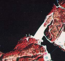
Portion of NAPP infrared photograph (1984). Lake Jocassee is in the upper left (black) and the hydroelectric dam is in the center. The Keowee River is to the lower right (also black). |
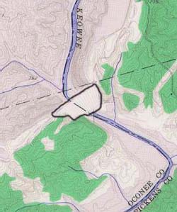
Portion of topographic map from the Salem USGS quadrangle (1959). Lake Jocassee is in the upper left and the hydroelectric dam (outlined) is in the center |
Lake Jocassee (NAPP)
|
Lake Jocassee (Topo)
|
RationaleThe Lake Jocassee Region Study Area is a prime wilderness location characterized by rugged mountain topography, scenic waterfalls, pristine trout streams, and unique habitats which are home to more than fifty rare plant and animal species. Because of the undeveloped nature of this region, both the federal and state government, along with private groups such as the Nature Conservancy, have established a series of parks, preserves, and wild-and-scenic river corridors to help preserve this wilderness area for the study and enjoyment of future generations. Lake Jocassee is one part of a series of dams and reservoirs constructed, operated, and maintained by Duke Power Company, to provide electricity for the citizens residing in upstate South Carolina. The rugged topography is ideal for power generation by standard hydroelectric plants as well as pumped storage technology. Lake Keowee also provides cooling water for the Oconee Nuclear Station. The environmental demands created by power generation often conflict with goals of wilderness preservation. Duke Power Company, through their land management subsidiary, Crescent Resources, Inc., has established a winning partnership with state resource agencies and private organizations to provide the power needs of upstate South Carolina with minimal disruption to the environmental resources. |
Background InformationDescription of Landforms
Influence of Topography on Historical Events and Cultural Trends
Natural Resources, Land Use, and Environmental Concerns
|